TIRED OF TRAFFIC?
MAKE YOUR VOICE HEARD

Join Us for a Town Hall Meeting

Join Councilmember Steve Brandau for a Town Hall meeting to discuss the status of the Veterans Boulevard Project.

Mayor Lee Brand, City Manager Bruce Rudd, Public Works Director Scott Mozier and Tony Borden, executive director of the Fresno Council of Governments, will also be present to answer any questions you may have.

WHEN:  Wednesday, March 29
TIME: 6:00 – 7:30 p.m.
WHERE: Herndon-Barstow Elementary Cafeteria
6265 N. Grantland Ave.

Call Councilmember Brandau’s office at (559) 621-7820 or email district2@fresno.gov for details.

About the Project

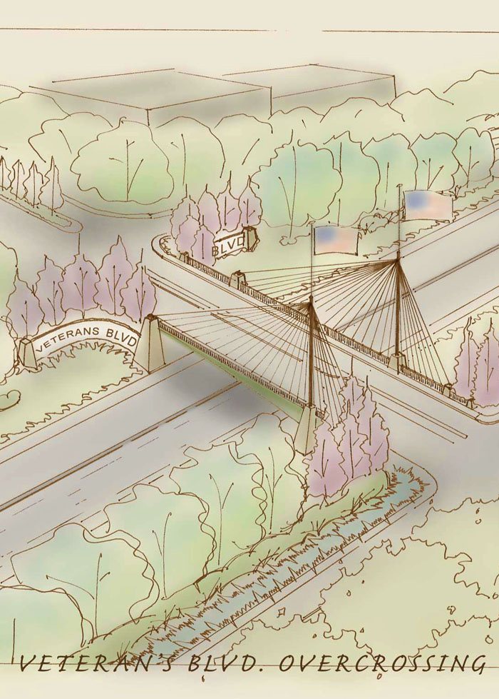
In 1984, the Fresno General Plan first introduced the potential need for Veterans Boulevard to serve the local community along State Route 99. State Route 99 is a four-lane freeway (two mixed flow lanes in each direction) throughout the project limits. State Route 99 is part of the California Freeway and Expressway System stretching almost the entire length of the Central Valley. Veterans Boulevard was to serve as a north-south “super” arterial to serve planned land uses in north Fresno.

The interchange would provide additional north-south access from State Route 99 between the Shaw Avenue and Herndon Avenue interchanges.

This idea was refined in 1986 with a feasibility study conducted to analyze potential interchange/grade separation configurations, with the intention of determining the alternative best suited to the site and the proposed Veterans Boulevard. In 1991 a Project Initiation Document was completed, and in 1996 the official plan line for Veterans Boulevard was adopted. Most recently, a project study report was completed to design the preliminary engineering as well as to determine how various alternatives might best serve the community.

Veterans Boulevard and the proposed interchange with State Route 99 are identified as part of the circulation system in both the City of Fresno and Fresno County general plans.

Purpose and Need

The purpose of the Veterans Boulevard is to improve accessibility to State Route 99 and circulation to roads adjacent to the proposed interchanges in northwestern Fresno. It would also provide congestion relief and improve traffic flow in northwest Fresno. Enhance the local circulation network that would accommodate local development and provide consistency with existing and planned local and regional development.

Improve Accessibility to State Route 99 and Circulation to Adjacent Roads

The proposed interchange is between two nearby freeway interchanges: Herndon Avenue to the north and Shaw Avenue to the south. These existing grade-separated interchanges are about 2.5 mile apart. Currently, many of the connections to State Route 99 offer only partial access and are limited to accommodate future demand. Crossing State Route 99 is problematic since many of the crossing locations are currently more than 1 mile apart and the capacity of these crossings is limited. Connections are also limited by the Union Pacific Railroad tracks that run parallel to State Route 99. These additional movements on local roads and highways contribute to overall congestion in the area and an increase in the number of miles vehicles travel. Level of service is a description of roadway effectiveness in transporting vehicles through a corridor. Six levels are defined, based in part on the number of seconds each vehicle is delayed.

Provide Congestion Relief

According to the 2025 Fresno General Plan, and Caltrans and Federal Highway Administration standards, an acceptable level of service rating for this type of roadway (highway/local roadway) is minimal delays. However, traffic analysis for the project identified five intersections and one roadway segment that currently operate at level of service. Under the No-Build alternative, levels of service would be deficient by 2015 at four intersections and ramps along Shaw Avenue during one or both of the peak hours, and at one roadway segment along Ashlan Avenue.

Under the No-Build Alternative, anticipated levels of service could worsen by 2035, with deficient levels of service during one or both of the peak hours at three intersections and ramps along Herndon Avenue, one along Parkway Drive, and one along Veterans Boulevard. Roadway segments along Grantland Avenue, Shaw Avenue, and Herndon Avenue are also expected to be at deficient levels of service.

The anticipated delays in travel time under the No-Build Alternative that occur at adjacent roads are due to projected future development along the State Route 99 corridor even though State Route 99 itself is expected to continue operating at acceptable level of service.

Enhance Local Circulation

The City of Fresno adopted an updated General Plan in February 2002 creating a land use blueprint for long-term growth to at least 2025. Regional transportation needs were assessed in the Council of Fresno County Governments 2011 Regional Transportation Plan. Land use forecasting indicates that population growth in the city of Fresno would continue to increase at a rate of 1.8 percent per year, increasing the city population by 56 percent by 2040 (California Department of Finance 2009).

As the city grows from development projects consistent with the 2025 Fresno General Plan, the demand for transportation improvements would increase. Traffic generated by future projects would use State Route 99 to access travel destinations in the region. Increased traffic would also occur at the Herndon Avenue and Shaw Avenue interchanges. Without the proposed Veterans Boulevard interchange project (i.e., NoBuild Alternative), level of service for these two interchanges would decline to unacceptable levels. To accommodate this regional growth, local and area-wide roadway infrastructure must be able to support increased traffic demand.